
Distance: 7.4 mi.
Elevation Gain: 4400 ft.
We started hiking along Sasse Mountain Trail from the upper trailhead at about 9:30 AM. We continued straight at the junction with the Jolly Mountain Trail. We followed the trail mostly east on a simple, straightforward, and partly shaded hike until we reached the north ridge of Jolly Mountain, then headed south along the ridge to the summit. We reached the summit of Jolly Mountain at 11:15. We saw one dirt biker on the way up and two other hikers as we were leaving Jolly, but that was it for the day.
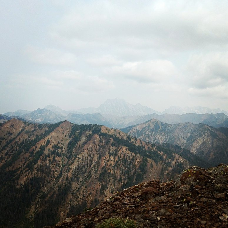
- Smoky views to Mt. Stuart
After enjoying the views over an early lunch we hiked down from the summit and then continued left (south) along the Yellow Hill Trail toward Humerus Hill. This trail was particularly rutted out by dirt bikes so it was slow going.

Quite a bit of the surrounding area burned in a 2017 fire so there was a lot of sandy ash on the trail also. We curved around the west side of a subpeak and then chose a random place to climb left along the scree slope toward Humerus Hill. We reached the top at 12:45 PM. It was a short climb up and the views were pretty good. Mount Stuart was subdued by a smoky haze.
From here, Craig gave me the option of returning the way we came like sane people, or going completely off trail between Humerus Hill and Sasse Mountain in order to take the Sasse Mountain Trail back to the car. I’m always eager to do a loop hike and Craig made it sound pretty easy, so I agreed to go rogue. We returned to about the halfway point between Humerus and Jolly and then turned left (southwest) on a relatively shallow slope toward the creek below. The vegetation on this slope was all completely burned away and the soil was quickly eroding, so our steps were pretty slippy and slidey. We made it to the creek below, over several downed trees, around 2:15 PM. We decided it would be easiest to follow the creek, but it did get challenging as we continued to descend because of thick brush in places and many downed trees.


At one point while we were hiking in the partially dried creek bed, a rock tumbled and I landed with both feet ankle deep in the water. Most people consider it a bad thing when they suddenly plop their feet in the water that they’ve been meticulously avoiding for quite a while. But my old pal Two-Sticks taught me that this is actually the “Freedom Step”, because you no longer have to work to avoid getting your feet wet. So I decided to go with this more cheery outlook and happily plodded through the middle of the cool, refreshing creek in my trail runners. Craig managed to stay dry by skirting along the sides. After quite some time, we reached the West Fork of the Teanaway River at 3:15, which we easily crossed and began climbing west along the valley toward Sasse.
We probably should have just stayed in this valley, but we decided to climb to the northeast ridge in hopes that we could easily walk along the top. But our hopes were dashed – the ridge wasn’t really navigable so we ended up sidehilling along the steep sides of the ridge. By the time we were halfway up Sasse, I was beginning to get pretty Grumpe. The issue was that almost everything we stepped on all day either sunk, rolled, or wobbled, so the stabilizing muscles in my legs were completely spent. The main thing keeping me motivated was thinking about eating the chicken that Craig had roasted the night before 🤤 (recipe). All the while, I tried my best to hike with a perky skip in my step because we had seen big cat tracks earlier in the day and I didn’t want to look a maimed straggler.

- The ridge up was trickier than expected. Jolly and Humerus Hill in the distance
Anyway, after what felt like the span of human existence we reached the summit of Sasse at 5:30 and… it was kind of an eyesore. The fire hit this area especially hard so all the trees were dead, and the views were obscured by an ongoing fire. We didn’t linger long before heading back down the Sasse Mountain Trail. Despite only being a year since the fire, a lot of the trail was buried underneath ash and fallen pine needles. But as long as you don’t do anything super wacky, you will be able to go in the general correct direction. We ended up a tiny bit below the car, so we turned right on the road. We finished at 6:30 PM.

- By the time we were headed back to the car, it was really smoky
(Download the free Gaia GPS app on your phone to view tracks and then get a Gaia GPS membership if you want offline access. Discount below!)

Recommended brew: Bellevue Brewing Scotch Ale
Gear Used:
- Trail runners
- Trekking poles
- “Embrace the suck” attitude
Post may contain affiliated links